Wednesday, September 25, 2019

Is Colorado really that rad?


Nylglo 140660 Colorado State Flag,3X5 Ft
Many years ago I was in a hut in British Columbia with a group of friends and the hut (Fairy Meadows/Bill Putnam) is big enough to hold two groups of people.  The group that we shared the hut with was from the Front Range of Colorado (aka Boulder/Denver and environs).  They were generally okay folks, and from what we saw were generally good skiers who were doing as good a job as we were at lapping up great powder runs.  After a few days I found myself sitting with a number of them over end o’ day beers and decided I had to know: “So, you guys clearly are good skiers and appreciate good skiing, and you are from Colorado, so I gotta ask:  what’s the backcountry skiing like in Colorado?”  They enthusiastically took turns telling me what it was like to be a backcountry skier in the Front Range, and after quite some time one of them asked: “Well, what do you think?”  I thought for a moment as I pondered my reply, and finally shrugged and said: “I think that if I lived in Colorado, I simply wouldn’t bother to go backcountry skiing.”  Suffice to say, that pretty much ended that conversation, and for that matter any subsequent conversations between them and me for the rest of the week. 

Since then, I’ve done a good handful of trips to Colorado, and even been backcountry skiing in Colorado (once, at the dire-but-stable end of the horrific drought year of 2017-18), and I have grown to like it.  I’ve done a couple of great bike tours there with Ashley, a great bikepack trip with Fred Marmsater (part 1 and part 2), and have done a handful of mountain bike/paddling trips there to enjoy the Animas/Piedra, Blue, Cache Le Poudre, Roaring Fork, Crystal, Yampa, Delores, Colorado, Taylor, Arkansas, and Gunnison rivers and their nearby trails, including the past week when Colin Gregersen and I hit up the last few of those. 
Colin paddling Number 1 on the Arkansas River's Numbers section. 
 
and slaying singletrack high above Crested Butte
Every time I visit, I’m struck by salient fact:  people love to love Colorado.

In Utah there are almost daily sightings of the red “U” of the University of Utah and the Blue “BYU” of, well, BYU on people’s cars, house flags (like the new guy next door to us, so we are forced to see “U” daily), Tshirts, and hats. It’s the same in every state, and it’s probably a function of identification with an esteemed alma mater or simply a football thing.  But Colorado is different:  people display memorabilia showing the Colorado flag.  I’m sure that University of Colorado and Colorado State have their fans, and of course they even have their own NFL team, but you don’t see too much memorabilia from those institutions; instead you see people wearing the big sunburst C hats on Tshirts, sweatshirts, and stickers on their cars.  I doubt that many Utahns would even recognize the UT state flag, much less be proudly sporting it on their head.  So relatively speaking, Coloradans seem like a proud lot.
 
Our shuttle driver Joe was not sporting his CO flag hat or shirt this day but no doubt he has plenty. 
And they should be: Denver is by far the most significant city between Chicago and the biggies of the West Coast, they have lots of nice mountains and rivers, pretty favorable weather, and a thriving economy. But every time I go I seem to find that people are awfully smug about it, yet  - for sure, like everywhere – there are some flaws. 

My hut mates who regaled me with tales of backcountry skiing in ‘Rado pretty much told me a narrative that to me seemed filled with traffic (that comes in two parts:  desperately weaving through the gauntlet of the Front Range maze to even get close to getting into the mountains, then tackling the 2-lane parking lot known as I-70), big avalanche-prone terrain filled with precariously-loaded windjacked snow, and backcountry crowds.  The Colorado resorts have a skier density of 427 skier days per acre, which is over twice as high as Utah’s 180 skier days/acre (ironically, there used to be 175 operating ski resorts in Colorado; now there are only 30).  But boy, those three weeks of spring skiing after Independence Pass opens and before it all turns to suncups, the skiing is great!  The rivers are nice, but the shortness of the good sections makes the paddling feel a bit contrived and the prevalence of private property on the banks of many rivers and their belligerent owners has been such an issue that American Whitewater has 4 of their 8 staff members based in the state. 

Ah, but the mountains! The Fourteeners!  There are so many!  Yes, there are 53 peaks over 14,000 feet, but I would guess that ‘Radoans hate the fact that they are all slightly short of California’s 14,500 foot Mt Whitney (but Cali only has eleven more fourteeners!).  If I ever feel like poking a Colorado native a little I say something like: “the great part about Colorado is that  - unlike some other western states - all your big peaks are so easily accessible!”  The long history of mining in Colorado basically created an amazing network of mountain roads (that make for great cycling) and indeed it’s a great asset for people who like to efficiently get into elevated mountains. 

Speaking of elevation, people love to be high in Colorado.  I could of course be referring to the tired old trope of “high” as it’s associated with their pride in being the first to legalize pot, but I’m actually referring to the even more-tired trope of the elevation of most Colorado places.  I usually hear what elevation every ‘Radoan lives at within the first few minutes of a conversation with them, but the truth is that I probably already know, because I am regaled by their city signs that don’t bother with population, just their elevation:


Sedgwick?  and only 3500 feet?   
 and of course, the Granddaddy:

Actually, it probably saves money; the elevation never changes, so the signs don’t need to every after each census!

Perhaps Coloradoans are just exhibiting yet another example of the tribalism that seems to be getting ever-more entrenched in our society. I just saw a quote from a book called “Sapiens” that “Humans evolved to think of people as divided into us and them.”   So apparently it’s natural for “us” to think of “them” as having lesser mountains/beauty/recreation? And the tribalism can be also get to the fraternal level; Colorado is the only place I know where people actively cultivate "secret" trails that the kool kids try to keep the gumbies away from.  
 
Of course, anyone who lives in Colorado who is reading this is probably at best offended (but I’ve probably lost them by now) and at worst furious and can’t wait to take me out and kick my sorry ass by skiing the likes of Capitol or Pyramid Peaks, running Nolan’s 14 or Hardrock, paddling the Crystal Gorge and Yule Creek, riding the Colorado Trail Race, climbing the Diamond, or climbing the walls of the very intimidating Black Canyon:

Colorado does have great stuff, and I do indeed keep going back: last week I declared that the mountain biking there is better than Utah’s (there seem to be more trails and they seem to me to be rockier/more technical/longer:
I walked a lot of sections of this trail

I don't do this much on Park City's buffed trails; if “better” is “harder” then it’s better in Colorado
There’s a lot to be said for accessible mountains (once you get into them), short and good rivers are better than an almost utter lack of rivers (Utah), depending on where you are there’s decent proximity to the (Utah) desert (which, to be fair, Utahns also love to love), and the west slope’s fruit-growing ability is legendary:
them Palisade peaches are big, juicy, and tasty!
 It’s also refreshing that Colorado’s civic leadership understands the value of recreation and invests in it:  there are kayak play parks in every town with a river (including downtown Denver), many, many miles of nice and/or convenient bike paths, ice climbing parks, and the state seems to be a fierce protector of existing open spaces and actively promotes trail building and use, which ultimately contribute to the state’s reputation and economic success.  Contrast this to Utah’s leadership, which inexplicably ignores examples like the incredible economic growth that has happened around the original Grand Staircase-Escalante national monument and instead values federally-subsidized grazing for a handful of ranchers and supporting the dying coal industry in addition to trying to sell land to extractive uses over the recreation industry (though Colorado also was one of the first states to really embrace fracking, among other extractive industry endeavors). 

So while anyone from Cool-orado probably would angrily tell me to “get out and stay out!” of their lovely state, I’ll no doubt continue to return and enjoy what Colorado has to offer, and instead of poking people I’ll be outwardly envious of so many 14ers, admire their many little rivers, sing the praises of their mountain biking, shake my head at how great it is that they have legal weed I don’t smoke, and of course ask them:  “and remind me again at what elevation live at?!!?”  

 
Yee-haw!  I'll be back!  


Sunday, September 8, 2019

Middle Kings - on the water.


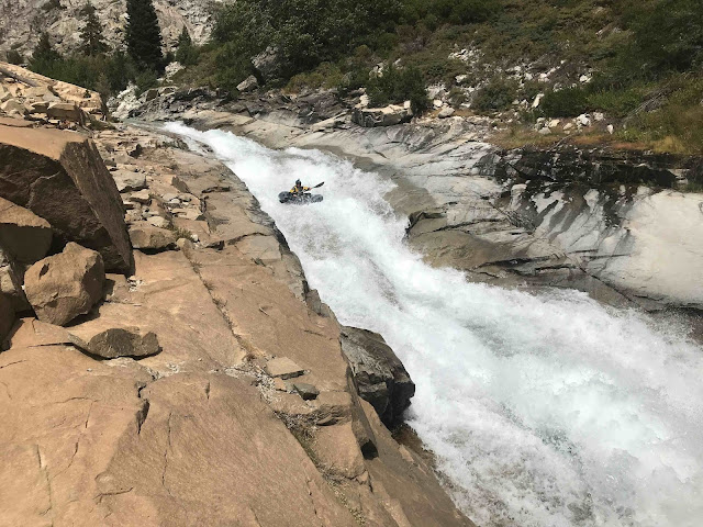
John  Baker cooly paddling away from a nice drop in the heart of the canyon.  This pic and all the rest are by Dan
The moment had come; we’d hiked way into the Middle Fork of the Kings river with our boats, there was enough (too much?) water, the crew was psyched, and it was time to blow up our boats and get on the water. 

Despite the thunder of the waterfall and the adjacent hard granite slab we were perched on that had a pretty decent slope towards the waterfall (watch your rollable gear as you pack up!) we all had slept well, and we hiked the remaining mile or so up towards the confluence of Dusy and Palisade creeks where the Middle Kings officially begins.

As we were geared up and ready to put on, Dan – being the Swiftwater Rescue instructor that he is – suggested we have a discussion about safety.  Dan, Jeff, and John have paddled together a lot on challenging rivers and know each others’ strengths and characteristics well, but even though I’d paddled with Jeff this summer it was still a new dynamic, and I was happy to oblige.  Of course, we’d had two full days of hiking to chitchat  - and I do that a lot! – but trudging along a trail is a far cry from firing down a steepass river in the middle of nowhere, so it’s good to establish strong connections, communication, and expectations.  And I won’t hedge here; I was nervous.  It was pretty clear to me from our hike up that this was going to be the Real Deal trip; even though there was a nice trail along the river, this was a strong team that was capable of paddling a lot of it and was intent upon that, I hadn’t done a river of this magnitude in a long time (I had mentioned this to Dan and John a coupla times on the hike up, and they no doubt were wondering “well, what the hell are you doing here then?”  which would have been a fair question!). 

With that, we put on.  As with every challenging river, we simply worked our way downward in the typical fashion:  peering over horizon lines, getting out to scout, setting safety for the bigger ones, and firing down a lot of great rapids.

The drops were big, but were of the granite slide type that Jeff and I had done on our upper Cherry and upper Merced runs, so we had a better sense of what rapids would go and what the friction/speed would be like with our pack rafts.  However, like those runs, there was enough water that the hydraulics at the bases of the slides were pretty meaty, and while the packrafts can be good at skimming over holes if you can keep the bow up, they also descend slides more slowly than hardshell boats and naturally buckle a little when they hit holes and this combo can buck the boat back into the hole, so we had to adjust our expectations of success accordingly, which generally worked out well. 
Me keeping my bow up!
As I expected, Dan and John were very solid paddlers and Jeff  - as the only non-hardsheller in the group – continues to ascend a steep curve of super strong pack raft paddling, and things generally went well, though we all took our own swims; we all have fairly solid pack raft rolls, but the occasional hole thumpings, head/shoulder rock bashing, or up-against-the-wall roll attempts brought us out of our boats, fortunately only briefly with no lost gear. 

John was willing to give one of the biggest slides a go, and it was an impressive mount up:
We were all concerned about the hydraulic at the end, but there was a weakness in it that seemed bustable, and combined the speed of the concentrated flow at the bottom was impressive:
But indeed, the hydraulic was powerful, and it's tentacles pulled John back into the hole from 10 feet away despite his strong exit strokes
a challenging rodeo ride.
A notable section is Waterfall Gorge; a half-mile long section with 4+/5- drops that ends in a picturesque waterfall:
I was a little spooked by the holes in the upper drops (especially the last one above the falls) and the commitment level of the gorgette, and just below this falls was a gnarly little slot, so I portaged the whole thing.  However, Dan and Jeff fired it up and it went well, tho I didn't think to bring either of their cameras and John - with a sweet camera - has been busy preparing for a big move and hasn't been able to deal with his pics yet, so you'll have to imagine Dan/Jeff firing over the lip of this beauty!  

California is known for it's big, marquee pool drop rapids, but the Middle Kings is different in that there are innumerable STEEP and complex boulder gardens.  The going was slow with long scouts:

and some creative portaging:

But we were able to paddle some of the best rapids we'd ever done:


Occasionally the gradient would taper off for some relaxation:
Until it picked back up

Eventually the mighty Tehipite Dome came back into view:
And we knew that we were nearing the beautiful Tehipite valley that signaled the end of the pretty steep and challenging section and the beginning of the really steep and challenging section.

We camped at the base of the dome and I did a lot of pondering.  What we had done so far was incredible in many ways:  beauty, high quality of rapids, challenging but paddleable.  The infamous "Bottom 9" (9 miles, actually more like 8, with a half-mile of that being the flat Little Tehipite Valley" lay downstream, and we had little information on it beyond "very steep and challenging with lots of complex rapids and portaging."  I'd been having fun and paddling just fine, but realized that virtually all of the hardest rapids I'd paddled in a pack raft had been over the last couple of days, and I wasn't sure I was ready to take it another potentially big step.  The trail that we had come in on was right there, and once beyond it there was no exit for that steeper section.  I had taken a pretty big rock hit on my ass on a slide and slipped once while portaging and banged my quad hard, and the non-Vectran (ie less durable) boat had taken some damage on the sharp granite.

But mostly I was nervous; the increased gradient and Willie Kern's warning of potential sieves gnawed at me, and by the time I awoke I realized that I was out.  It was difficult; as Ashley knows well, I get FOMO as much as anyone, and I like to think of myself as game, tough, and resilient, but I also have learned - mostly from backcountry skiing - that knowing when to back off engenders longevity, which is really the most important thing.  I was super psyched to have made it down that far, and as the boys rigged up and I bid them adieu, I was ok with my decision.

Of course, trudging hard for 7 lonely hours up out of the steep Tehipite valley and rolling back through the boring woods gave me plenty of time to kick myself for being a weenie as well....

As it turns out, my pards of course made it through the bottom 9, and indeed they said that it was even more of the Real Deal than the sections above.  Below that is the 14 mile Garlic Falls section - that I paddled a few eons ago - that is famously aesthetic:
But also provided a fair bit of challenge, especially since the volume is doubled with the addition of the South Fork of the Kings.   But all went well, and thus the first pack raft descent of the Middle Kings was completed (though Dan had the good point that distinguishing between pack raft descents and hardshell descents just tends to create more unnecessary differentiation).

Huge thanks again to Jeff, Dan, and John for letting me join their posse and being super solid partners for a challenging adventure, and thanks very much to Dan for all of this post's great pics. 

Thursday, September 5, 2019

Middle Kings - an even bigger pack raft adventure!


We’d been at it for four longish days:  two days of hiking about 20 miles each, then two more days of paddling  - and portaging - some of the hardest rapids we’d ever done in pack rafts, deep inside the Kings Canyon National Park Wilderness.  The scenery alone was worth the journey; we were less than a hundred miles from Yosemite in a valley with essentially the same geologic makeup, with a white granite dome that soared a higher-than-El Cap-3500 feet over the steep river valley we shared with exactly….no one.   We were slowly working our way down the Middle Fork of the Kings river, and camped just above the most notorious section of the canyon, with an exit possibility.  I’d been paddling at my limit and having a nice time doing so, but with 2700 feet to drop in ~8 miles my limits were going to get pushed. Do I take it the exit or forge on downstream? 

In August of nineteen hundred and ninety seven I bumped into the mighty Kern brothers: Johnny, Willie, and Chuck, at the summer Outdoor Retailer show in Salt Lake.  They had driven hard across the Nevada desert to reach the show in time to work it  - as some of the early “professional” kayakers getting sponsorship - after doing a descent of the Middle Fork of the Kings.  It may have been only the second descent; the first was done by Reg Lake, Royal Robbins, Doug Tompkins, and Newsome Holmes in 1982, where these extraordinary first descenteers (not just here, but all over California) declared it the hardest run they’d done.  

A fun pic I got a few years ago at the OR show:  Reg Lake is far right, with other legendary kayakers (l to r) Chris Spelius, John Wasson, and Rob Lesser
But it was a new era of shorter boats, better plastic, and more honed skills, and no doubt the Kerns and their pards likely did first descents of most of the rapids the pioneers had portaged.  


 The numbers were impressive:  12 mile hike in over 12,000 foot Bishop pass, 44 miles of river, an average gradient of over 200 feet/mile, and a few miles over 400 feet/mile.   These guys were the best in the world, and they said the Middle Fork Kings was pretty mindblowing in many regards, including of course, difficulty.  Not long afterwards was the release of one of the first of the new generation of kayak videos called “Liquid Lifestyles”, made by Scott Lindgren, one of the Kerns’ go-to pards, and I was absolutely stunned by the magnitude of the whitewater.   I was paddling some of the garden-style class 5 California rivers at that time, but this was clearly a big - and probably insurmountable - step up for me. 

In the ensuing 22 years the Middle Kings has become world famous among the gnarly dood (and doodette) kayak world, and John Muir Trail and Pacific Crest Trail hikers have been surprised in the late summer to see people lugging hardshell kayaks that tower over their head and are filled with camping gear and a weeks worth of food up and over Bishop Pass.   Images and videos of epic-ly long granite slides and huge drops in steep gorges against a stunning backdrop pepper the interwebs.  I didn’t think too much about it; my class 5 exploration days had kinda waned due to drought, pards that faded away and (mainly) living in a desert, but then pack rafts came along.  Since pack rafts are great low-water crafts more people have been able to paddle them on runs that are typically done in hardshells at much higher flows.  After a fortuitous bump into Willie Kern a year or two ago I followed up with him via email and asked him what he thought the Middle Kings would be like at low flows.  His answer:  still hard, probably pretty laced with sieves (where water rushes through rock gaps that a kayak would not fit through; sub-optimal for the craft’s captain).   Made sense to me, so I kinda forgot about it again. 

Until this year.  After two trips to California where I was able to join pack rafting Wunderkind Jeff Creamer (Jeff is no doubt the best never-has-hardshell-kayaked pack rafter in the world) for trips down the upper Tuolumne, upper Cherry Creek, and upper Merced it began to seem reasonable that the Middle Kings might go as well.  So when Jeff said that he and two super-solid pards of his from Durango were going to give the Middle Kings a go, I decided somewhat abruptly to jump on board. 

I will admit I had a fair bit of trepidation; Jeff’s thought was to head in when the Kings river gauge was dropping below the low side of medium, which was definitely not “low”.  Based on this, we would likely have between 300 and 500 cfs, which turned downhill steeply enough (like 2-500 feet/mile), can create some ferocious whitewater.  However, Jeff’s unusual idea to take advantage of the hikeability of the pack rafts by walking in from the West instead of over Bishop Pass (thereby taking the shuttle from 8 hours to a couple) and then walking upriver would give us a chance to scout the run as walked up, and since I knew the valley would be magical, I figured at worst it would be a great backpack trip (albeit a heavy-ish one, with the boat and assorted paddling gear). 

In addition to the rapidly-improving Jeff, his pards from Durango were equally strong lads who could not only paddle, they could march as well, which is important in pack rafting.  Dan Thurber has been paddling since he was a kid in Eastern Oregon and has spent many years at the class 5 level in a hardshell and teaches swiftwater rescue classes, and John Baker is another strong class 5 hardsheller who’s paddled all over the world.  Both have taken to pack rafting and have been pushing the limits of the crafts with tons of laps on Vallecito Creek, and the three of them have had recent impressive descents of Colorado’s Los Pinos Creek (jeff Video) and Wyoming’s Bull Lake Creek (Dan’s blog).  It didn’t take me long to recognize that these were young, talented, interesting, and solid guys to head out on an adventure like this one.

The hike in rolls through surprisingly (for the Sierras) nondescript terrain for about 13 miles to the edge of the canyon, but the view from the edge makes up for the previous dullness.  The view of the 4000-foot deep valley that sprawled below the soaring spire of Tehipite dome was simply outrageous:

Even though the view kept up on the descent down into the canyon, we couldn’t really look up at it; the super steep gradient of the trail that was covered with slick oak leaves over a decomposed granite surface with poison oak lacing the edges of the trail demanded full attention, and by the bottom my quivering, quaking quads were the focus of my energy. 

At the bottom we had a bigger perspective of Tehipite Dome:


and while typical national park trails look like this:

Our trail was a bit more primitive!
We had to be attentive to actually stay on the trail as we headed upriver, and lost it more than a coupla times, tho the bear scat helped keep us on track, since clearly bears like trails too.

As we climbed we had periodic views of the river, and what we saw was actually pretty encouraging, with a fair bit of what appeared to be class 4 boulder gardens:


Of course, rapids always look a lot easier when you aren’t geared up and about to peel out of the eddy and commit to the looming horizon line! 

We did see some of the infamous meaty rapids that we assumed would be portages once indeed we were geared up and heading downstream:
foreshadowing!
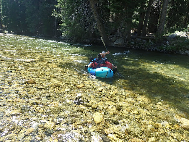
And we were psyched to be able to have boats for a mandatory crossing of the river:
This was probably thigh deep; not a big deal but enough that walking across with a heavy pack would have been a challenge in the middle.  In anything other than summertime flows crossing the river in this meadow would be a bit desperate; perhaps that is why our trail was very little used!
Another full day of hiking upriver brought us to a beautiful granite slab adjacent to a long thundering slide, about a mile below where Dusy and Palisade creeks combined to form the Middle Fork proper, and where the John Muir/Pacific Crest trail combo passed by on their way to the LeConte ranger station. 

Once at camp, Jeff and John decided to quickly gear up and head upstream for a half-mile of paddling back to camp to get a sense of how the river was, since the short bit above camp looked promising.  They arrived back at dusk, with a report of “yah, it’s pretty real!”  With that experience and comment resonating in our head and the white noise thunder of the huge slide just feet from our feet, we went to sleep wondering how the next few days of paddling the mighty MF Kings was gonna go. 


to be continued....

thanks to Jeff Creamer for the pics...