Thursday, November 20, 2014

Kayaking SoCal

I was digging through some stuff the other day and found a copy of the Fall 1998 Patagonia catalog where I "got my first big break" of an essay that was published there about a memorable day of local kayaking.  We are leaving Friday for bike tour of Vietnam which hopefully will create the opportunity for a somewhat-worthy tale, but in the meantime I thought I'd throw up the Patagonia essay, if for no other reason than it happened about this time!   

During the fall of 1997 SoCal was all abuzz about the presence of a BIG El Nino event happening, and by early December we were getting a little tired of hearing about this inevitable onslaught of storms we were going to receive while continuing to bake under a hot sun.  But then it all changed....

For the past 2.5 years that I’ve lived in Ventura I had had quick glimpses of the North Fork of Matilija Creek while riding my bike in the Los Padres National Forest 15 north of the Patagonia offices.  It’s a cool little creekbed that winds its way down through the chaparral and provides shady relief from the summer heat in its pools.  The gradient of the creek is 150-200 feet per mile and although it was hard to imagine on parched summer days that this little riverbed with only a few cups of water trickling down its rocks could somehow grow into something that could float a kayak, I couldn’t resist a wishful, Oregon-born thought as I pedaled home:  That creek might actually go if it rained, and rained A LOT.”

In December, El Nino cometh.  A small crew of whitewater boaters from rainier regions of the country who had been lured to gainful employment at Patagonia eagerly followed weather.com as the first major front of the season stomped its way across the Pacific.  The rain started on Friday morning, and it poured all day.  We went to sleep that night to the sound of rain still beating on the clay SoCal roofs, music to our ears.

Saturday morning we were happy to discover that the storm had produced nine inches of rain in Ventura County and most of SoCal was under water.  “Makes for some prime boatin’!” I said to myself as I drove to meet the others at the office.  We loaded the boats on top of our cars and headed for the hills. 

Our first sight of the river was below the confluence of the South and North Forks.  Bank-full and raging over the road.  As we stared glumly at the chocolate water we were incredulous; after literally years of dry weather we were going to get flooded out!  But as we continued up the North Fork it became obvious that it was only providing a fraction of the total river volume, so our rose slightly.  Scouting from above, a couple of drops looked do-able, but years of little to no water had enabled the alder, ash, and Manzanita to engulf the riverbed.  The possibility of strainers on such a tight, steep creek seemed high, and we had all lost friends to kayaking accidents earlier in the year.  However, our desire to get some fresh water back into our noses and the awesome potential of a “find” so close to our adopted home overcame our trepidation and we put on.

Soon it became apparent that the gradient was consistent, the class 4  -4+ rapids were surprisingly clean, and the rainwater dripping from the desert chapparal provided an iridescent backdrop to the creek.  I was finally paddling the Matilija, and it seemed like a totally new place to me.  We bounced down the creek, scouting and running each drop, naming the bigger ones “Conglomerate” (a thick boulder garden), “Waffle Wall”, (with some cool sandstone texturing on the bank), and “Let’s Make A Deal” (don’t pick the wrong “door”?).  Our excitement increased with every crazy twist and drop in the river, and it was quickly becoming apparent that we were discovering a gem in our own backyard. 

It had taken three years of waiting and over nine inches of rain, but by the end of the afternoon we had completed our first run of the North Fork of the Matilija.  On the 20 minute drive home, while peering through our beloved rain, we decided that Ventura-by-the-sea was a pretty good place after all for a bunch of displaced paddlers who have fresh water running through their veins.  We weren’t home, but we were closer. 

If we took pics that day they are long gone, but here are a couple of pics of the NF Matilija Creek as it looks normally:


The rest of the winter delivered as promised; the rains kept coming to the point where SoCal was in a federal disaster area for months and we were able to paddle rivers and creeks that hadn't had water for at least 10 years.   We almost got arrested for kayaking since the local authorities had no idea how to treat us and we had to research California river navigation laws to make sure the laws were on our side.  

Since that 97-98 winter it may possibly have rained enough for the NF Matilija creek to be almost runnable for a couple of days each in 2001, 2003, and 2004.  2005 had some big rains that definitely created enough flow.  It has likely not had more than a trickle in it since 2005.  A rare gem indeed. 


Sunday, November 16, 2014

Contrivization....or, "does it have style?"

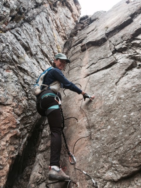
Some weeks ago Ash and I went up to Ogden to spend a half day on the via ferrata system in Waterfall Canyon.  Via ferrata is sort of an interesting deal that got it's start in World War I as a way to move troops around in really steep terrain; the "iron road" is basically a route put in up/through  cliffs that uses rebar embedded into rock as "holds' (ladders) with an associated cable that is fixed every 10 feet or so in order to clip into it and have bomber protection in the unlikely event of a fall.  It's apparently gotten really popular in Europe (particularly in the Dolomites) since it has appeal to those who may not be into 'climbing" per se, and even for the gnarly mountain dudes it can provide a conduit to covering ground in sections that might otherwise be too scary to solo or blast through unprotected.  Some years ago famed climber Jeff Lowe worked with a few folks in Ogden to put one up on the steep cliffs of Waterfall Canyon and even though it's been sorta low on the list of things to do it's been on said list long enough that it finally rose to the top, so we went up to give it a go.

It turned out to be really fun; there are three routes that go from easy to harder and it's pretty straightforward; just start climbing up a rebar ladder with rungs that are bent into a U with the ends embedded in the rock, periodically use the rock as steps, and always keep one of the two locking carabiners clipped into the adjacent cable for protection.


Ash getting going one one of the routes

The two more-advanced routes feel a bit airy; lots of exposure and quite steep to even overhanging.  For someone not comfortable with exposure it can be a bit exciting.  But because people can do it together, it's easy to be "right there" to provide support to someone who might be intimidated, as opposed to the more-typical yelling very generic and not-very-helpful "support" from far below when doing "real" climbing. 
you feel kinda "up there"
 It's a fun way to spend a morning or afternoon.  However, I kept having a word creep into my head:  "Contrived".  


Is taking a perfectly good crag with a couple of good pitches-worth of fine climbing on it and throwing hundreds of pieces of rebar on it to make it easy and approachable for practically anyone "contrived?"  Absolutely.  According to the interweb, the definition is thus:
        1) deliberately created rather than arising naturally or spontaneously.
  • 2) created or arranged in a way that seems artificial and unrealistic.
By this measure the Ogden via ferrata is indeed contrived. And reading spray on the interweb indicates that others feel the same.   However, it begs a couple of interesting questions:  what isn't contrived?  And another one: does it matter?

For us types who like to spend our times in the mountains, we typically do so in a variety of ways:  hiking, cycling, skiing, climbing, running.  All are great.  But the truth is that all are...contrived.   We get plastic buckled boots, carbon fiber skis, and fancy bindings to go play in the snow.  We use $5000 contraptions to ride trails that are cut to 6% grade-perfection.  We climb crags and protect them with bolts every 5 feet.  Even more "pure" activities like traditional climbing are a bit contrived:  we piece together a viable line on a crag, put in mechanical protection, tie up slings and place bolts/change to get off climbs. The fact that it is done via naturally-occurring bulges, cracks, and holds is nice, but the truth is that we are the unnatural, artificial components to the climbs; ie - we aren't lizards!  And hiking and trail running are great; but again, most of the time it's done on trails that were cut by motorcyclists back in the day or a modern-day trail cutter.  

But really, who cares?   We all just do these silly activities for fun, so why does it matter how we do them?   Apparently, however, there are many people who feel that the style in which we all do these activities is of utmost importance.  We have a good friend who seems to be acutely aware of - and critical of - the "style" of outings: was it done maintaining the highest possible line?  Was it descended from the top?  Were you in lockdown or tele? (that one seems almost moot these days!).  Was it done in one continuous push?  Did you fire it down the middle or sneak it down the side?  It seems like there's a distinctive period in the evolution of doing these activities that comes after the initial, naive, enthusiastic participation where people seem to care too much about how the activity is actually executed.  The Community has allowed that The Activity shall be performed This Way, and The Community looks far down its nose at folks who do not perform in the manner of The Way.

One of my favorite examples of this is the road bike criterium:  at some point The Community has decided that going around the same flat, uninteresting, 4-corner, half-mile city-block course as many times as you can in an hour is of Utmost Importance.  Thereupon many folks are willing to not only focus their entire weekend around that hour and shell out $45 for the opportunity, but also risk their egos, expensive bikes, and life and limb to do so.  Contrived?  Absolutely!  But it's super exciting and fun, and therefore worthy.

But over time some folks realize that The Way is not necessarily the only way:  it's ok to ride a bike without your legs being clean-shaven and wearing your kit.  It's ok to climb a trail that is typically used as a descent.  It's ok to stop short of the summit if that's what the conditions/situation dictates.  It's ok to climb the route via a different variation.  It's ok to ski the south face when the north face is "better".  And you can even do those unusual things with "style", if that's an important value.

And you can "climb" a via ferrata!  Sure it's contrived, but it's all about fun and enjoyment - while not at the expense of others' fun and enjoyment - and not necessarily about style.  But if style is important to you then do with your own sense of style, contrived or not!


Tuesday, November 11, 2014

Double Crossed!

Over the last couple of weeks I've been a little mopey since I had a last minute invite to join a Grand Canyon river trip with the Cincinnati and New England Canyoneering clubs and felt like I had to decline it, which initiated a severe case of Fomo.  But of course the fall weather in Utah has been stellar, which means there's been a plethora of opportunities to get outside and dull the insidious effects of Fomo, and I also was looking forward to the opportunity to join Chris Adams on what apparently is one of the hallowed rites of passage of ultra running: the Grand Canyon double cross, aka Rim To Rim To Rim (note the caps; that makes it more impressive), aka - if you are really in the club - the r2r2r.

It's pretty straightforward:  start on one side of the GC, run down to the river, run up the other side, ring the bell on top, and go back.    There are a couple of options on the south side of the canyon, so depending on what is chosen the route varies between 42 and 50 miles, with about 11k of vertical.  Straightforward indeed, other than the fact that for some of us (me) it's almost 50% further than the longest run ever!  And the National Park website doesn't really seem to encourage it:  "Under no circumstances should you attempt to hike from the north rim to the river and back in one day! Do not hike during the hottest part of the day."
Maybe they meant "don't do it before also going up to the south rim before going back"?

Because the North Rim is 200 miles closer to SLC than the South Rim, we elected to start there, and it worked out well that the "North Rim is closed" (despite being at the end of a state highway) so we didn't have to worry about getting rousted out of bed by an over-enthusiastic ranger uptight that we were illegally camping (not really 'camping", per se; more simply "sleeping") at the North Rim trailhead on Friday night.  But we were rousted out of bed by a ginormous RV full of fired-up hikers doing a one-way cross who wanted to get an early start to catch a football game that evening.  Ah well, we had to get going anyway.


Heading down the trail pre-dawn
Chris led the way down the 6500' descent at a relaxed clip that we hoped would not be a prequel quad-crusher for the next big descent off the south rim, and after passing all the hikers we easily found ourselves at the transition where the North Kaibab trail becomes a really gentle grade that's very runnable.  With the right incentive you could really fly down this section, but with over 35 miles to go we kept it pretty restrained.
I'm sorta posing here; we were going the opposite direction; the south rim is far in the distance
I have been to Phantom Ranch a bunch of times on river trips and it's a nice place, but what I didn't realize is that just up the creek from the ranch is an gorge that is as beautiful as any in the Grand Canyon
But then again, this is the "Inner Gorge" of the river corridor, so I should have guessed that the creek would be doing the same thing.

Soon enough we began seeing the fresh-looking Phantom Ranch day hikers, easily identified by their plumage of khaki-colored REI clothes, leather boots, floppy hats, trekking poles, the ten essentials, and recently-showered smell and knew we were getting close to the river.   We also saw some other r2r2r runners, also easily identified via their skinny calves and distinctive markings of puffy shoes, gaudy gaiters, tiny packs and not-so fresh scents.  One of these runners looked familiar, and I asked in passing: "Is that Matt?"  to which the reply was "no, but I saw you at the Wasatch backcountry Alliance meeting the other night!"  Really?  what's your name?  "John Rich."  Oh, are you Grace's brother?  "No, but we went to high school together!"   A lot of connections made in a very short time.  And we bumped into Nate, whom we had met at the Vacquero Loco race in August; apparently it's a pretty small community of folks who do this stuff.  

Shortly after Phantom we hit the river, which Chris had never seen:  
And we were happy to see the daily mule train right at the bottom crossing the bridge, which meant that we wouldn't get dusted/whizzed on by the mules on the trail.
and we began our march up towards the rim.  The South Kaibab trail is a bit more direct and therefore steeper than the nearby Bright Angel trail, and it also seems to have more built in steps made of logs/rocks that can be a bit awkward to descend nicely, so we decided to go up that trail
Coupla cool guys

After a couple of hours of upward marching we found ourselves on the rim, with many of our fellow adventurers

To get a bit of a different perspective we decided to do a loop by going down the Bright Angel trail, but the thought of shuffling along the rim on a paved path didn't sound very appealing so we took the shuttle bus the few miles over to the Bright Angel trailhead.  It worked out fine, but certainly takes a bit away from the "style" of the outing:
Chris given'er super hard on the shuttle bus

Busting Chris selfie-ing on the rim with our fellow adventurers

and back downward into the depths we went.  

Bright Angel is a slightly "nicer" descent, but it's still wide, dusty, crowded, and full of mule poo, but at least the width allowed us to zip past all the hikers who expected us to stop and answer the questions of where we were headed and what we were doing.  We did notice that when it got narrow the uphill hikers were tired enough that they were happy to relinquish their typical uphill right away and let us by.  

It didn't take us long to get back down to the river where we had a pleasant mile or two heading back upstream to the Phantom Area.  We did encounter another mule train, which is hard to get past:
These mules are screwing up my Strava!  


And then we were back at Phantom for a quick refuel for the longgg grind back up to the north rim trailhead.  Every mile past Phantom was adding on to the TD world record distance ever run, but I was pleased to find that my legs and body still felt pretty good, so as we hit the meat of the climb I decided to start given'er a bit and was happy to still have good power there.  
The light started to get nice and the shadows long as the day waned, and I had to keep reminding myself to look around every once in a while to take it all in rather than simply stare at the ground (though there are plenty of places on that section of trail where too much ogling-while-moving could be a bit disastrous).  And after grinding up what seemed like far more switchbacks going up than we had danced down hours before I stumbled onto the paved lot of the trailhead, with Chris not far behind.  

The weekend continued with a fun quick blast down the Pine Creek slot in Zion on Sunday, where Chris pointed out that the neoprene of our wetsuits and the cold water we were swimming through created good recovery compression and icing!  

So while I didn't get to float the Grand Canyon and embark on all sorts of adventures that await down there, getting Double Crossed was a great alternative.  Thanks again to Chris for driving and being a great pard for a fun outing.  

some important stats that as a blawging ultrarunner I apparently am compelled to share:
Distance: Pretty far, but not too far
Time:  a while, but not too long
Gear:  shoes, clothes, little pack
Food:  me - coupla bagels, gorp, zucchini bread.  Chris - a bunch of weird energy food-like products. 
Calories: plenty expended, plenty consumed
Hydration:  mostly water-based