Wednesday, October 24, 2018

A Return to Cataract Canyon


In nineteen hundred and eighty three the biggest El Nino ever had slammed the Southwest with snow over the winter - including some unusual late storms - and a fresh-faced young engineer who had recently moved to Utah for the skiing got invited on his first river trip ever.  Brother Paul Diegel eagerly accepted, and not being much of a river guy yet he didn't really understand that the copious powder he'd skied at Snowbird that winter meant that not only were the Colorado and Green rivers  experiencing record high water levels, but that Cataract Canyon itself was notorious for being unusually huge and dangerous (arguably more so than in the Grand Canyon, that itself was experiencing huge flows - as documented in the great book The Emerald Mile  -as the dam keepers endeavored to keep Lake Powell from over-topping the Glen Canyon dam).  However, as it turned out, for better or worse, Paul wasn't able to experience the fearsome power of the rapid section of Cat at 120,000 cfs; after floating the flatwater section his trip discovered that the Park Service had literally closed the river at the head of the rapids, shut down all trips, and made everyone on the river get rides on jet boats back upstream through the flatwater back to Moab.  Paul later made a low water descent in '98 and has since done dozens of other rivers in all sorts of crafts since, but he hadn't been back to Cat in 20 years. 

A few years later another fresh-faced young lad named Scott Martin was brimming with all the confidence that a recently-awarded Ivy League diploma conveys, but after graduation he very distinctly chose not to follow his classmates into the high brow world of East Coast corporate finance or grad school and instead came back home to Utah to put that high-falutin' education to work.....as a river guide. 

Despite the fact that Scott's dad had helped financed that expensive education, Pepper Martin was supportive of Scott's decision, and in fact gave Scott something that even today is one of Scott's most prized possessions, and is worth a look:
Written in 1959, 10 years before publishing the iconic Desert Solitaire, it is basically the template for idealistic aspiring river guides' applications ever since, written in Abbey's trademark laconic style.  And it was all Scott needed to jump into the dirtbag world of river guiding. 

The first few seasons were relatively uneventful as Scott rowed plenty of trips down Cat at flows that ranged from low to medium.  Then 1993 came along; another big snow year in the Intermountain West!) and Cataract roared again.   As the snowpack melted and the river came up the company kept running trips at ever-higher levels and the guides got ever-more excited, as they shoulda been; there have been at least a dozen flush drownings of swimmers after raft flips in Cat, and the odds of flipping an oar rig at high water are quite good, even with those weirdly-huge and flat big water boats they use down there.  Here is a great quick video of a high water raft hole ride and flip: 


Scott did indeed flip a raft at the peak flow of 77,000 cfs, but he and his passengers survived the harrowing swim.   Here's a pic of he and his pals reveling in their relief:
Scott's on the left holding the sign.  
After one more season, which probably pushed his total number of trips down Cataract Canyon to over 100, Scott finally decided to get real and go to law school.   Since then he's gotten a family and taken them on many other rivers around the West, but he hadn't been back on Cat since 1996. 

So I knew when I threw out the concept of doing a self-contained pack raft descent on Cat this fall to a buncha folks, I had a pretty good hunch that both Paul and Scott (who both had new boats; Paul got a Gnarwal and Scott bought Paul's old boat) would be the ones who would be keen enough to actually make it happen.

Our trip started with a rappel to get down the "Lower Jump" of Salt Creek, a couple of miles from the Needles visitor center (where we got our way-too-expensive river permit). 
it's usually safest to rappel with your pfd on!
Our stalwart shuttle drivers were able to take our anchor and rope back for us, and were stoked for their own adventure in Moab for the weekend while we were on the river

going down into the drainage proper I put my hand on a big rock to brace on it, and the multi-hundred pounder - loosened by big rains of the last few days - suddenly rolled down towards me.  I was able to sorta spin out of the way and it only grazed my shin, but as it tumbled down and slammed into hard into another boulder I realized that I just barely avoided my own Aaron Ralston moment.
big rock.  fragile leg.  
Soon enough we were on a nice hike down Salt Creek


that was punctuated by another short rappel
the bros lapping up Salt Creek
Apparently there was so much water in the creek over the last few days that there were some microfish that got a bit stranded

Once at the river there was no inviting beach, but we shoved our way through willow and tamarisk to find a weird clearing to camp:
that Scott guessed was an old high-water camp.  

And after a dewy night we dried off and rigged for floating a couple hundred yards from the river
And we were off! 
Scott's first strokes in a pack raft.  
We had a few miles of flatwater to warm up on before we started into the rapid section
And then the rapids began:
boat-based pictures are invariably bad....
the rapid section of Cat starts small and builds up, with a couple of the rapids providing a bit of a kick before culminating in the "Big Drops" of BD 1, 2, and 3. The sunlight reflecting off the muddy water made it hard to see and we dropped into a couple of meaty-ish holes inadvertently, but quick recoveries ensued.  And the Big Drops went just fine:
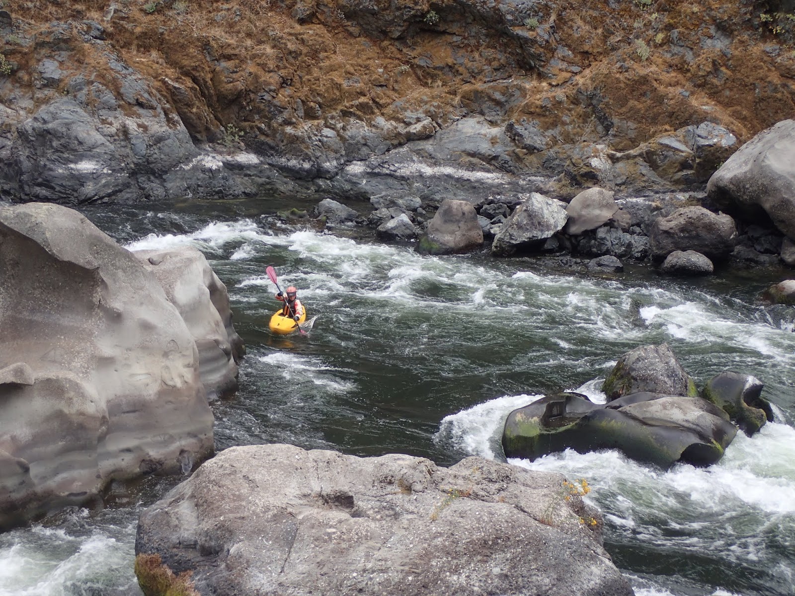
what looks like a mini boater perched on a rock is Paul lining up for Big Drop 2
sliding on through 
and then we were through and off to a nice beach camp:
celebrating Alive Below the Big Drops!
To be clear, the difference between the 7000 cfs that we had in Cataract Canyon and even 20,000 cfs is huge, much less the awesome power of 50k or 77k.  At 7k it's mostly class 3, with a couple of places where it's sorta pushy class 3+ or maybe 4-.   And this time of year the water is 60 degrees, so a swim is not very breathtaking. 

Once below the rapid section the river returns to it's formerly placid state, and we had a long paddle out, but now river runners are at least blessed with current.  Back in the day Scott's crews would mount motors on their rafts right after the big drops to motor "down" the lake. 

The Colorado River Compact was a 1922 agreement with all of the states that were reliant on the river for its water, and that agreement drove the development of the various hydro projects for the next 40 years.  In hindsight, water managers now realize that period prior to 1922 was unusually wet so the agreement was predicated on relatively rare large snowpacks and flows, and of course the crafters of the agreement could never have envisioned the extraordinary growth of river-dependent cities like Denver, Phoenix, Vegas, Salt Lake, Los Angeles, and their respective vast suburban communities that would become ever-more thirsty.  Couple that with a few droughts, and basically the reservoirs along the way have been in perpetual decline.  Lake Powell  -the terminus of Cataract Canyon (and the San Juan river) is now 60 feet below its average for this time of year, and 108 feet below full-pool, and considering that it's shoreline is 1900 miles, that's a lotta water that's not in the lake. 

As a result of the lower lakeline, the river in lower Cataract Canyon is back.   Not only are there rapids below the old lake line but there's actually current all the way to the takeout....for 30 more miles! Which is great, because while I feel like I'm allergic to lake paddling, if there's even a little current in flatwater I'm happy. 

There used to be a boat ramp called Hite on river left (the name was transferred from the small town of Hite that was inundated by the lake in the first place) but that outpost is now high, dry, and deserted.  And the silt that was deposited in the upper reaches of the lake now constitutes the river bank, though it's gradually calving off back into the river each spring when the high water starts licking away again at the base of the silt banks.  Paul had at least been to the Hite area over the last few years that he's been away from the river so he's seen the takeout area at the low lake level, but Scott was continuously amazed that what we were paddling through was literally 80 feet under the surface of the lake. Near the takeout he pointed out a spot where sister Michele had shown her collegiate diving prowess back in the day by throwing some stunts off a cliff; now the landing zone is a pile of rocks that are 50 feet out of the water. 

With sore shoulders from the unpracticed grind of flatwater paddling we hit the takeout where our erstwhile shuttlers awaited, and our little adventure was over.  Thanks again to Scott and Paul for being great pards on a fun trip, and I hope that we will again soon Return to Cataract. 

Friday, October 5, 2018

Paddling the mighty Rogue River


Once we had finished our little bike tour of the general Rogue zone we were perfectly poised to execute on the 2nd phase of our ideal adventure; the river trip!

But first, it occurred to me to throw up a map showing our general bike tour route:
Of course, within that are important details - like the excellent "Scenic Bikeways" in the Coquille and Elk river areas, and if there's any interest I have the gpx route that we took.

Only minutes after we finished our tour in the little hamlet of Galice trucks started showing up with kayaks on them, and our crew had arriven.  Although the official Rogue put in for the permitted section is a few miles downstream, there is a convenient campground nearby that allows for a pre-launch riverside camp, complete with volunteer campground hosts who take their "jobs" way too seriously.   Though Leigh and Matt have been great friends for a long time, they have also been gone a long time and have made plenty of "new" friends, so we tried to make the rounds to meet everyone even as everyone "rigged" their boats (ie stuffed gear into their kayaks, and one small raft) for our 4 day trip.

The first little bonding experience our new group had was navigating The Big Rapid, Rainie Falls.
cool pano shot by Matt
According to the little info stand at the lookout far above the falls that we happily took the time to read on our bike tour, the falls  -like most - is formed at a geological break between two different types of rock.  But early river runners put in the effort to subdue later efforts by blasting out a more-gradual fish ladder adjacent to the main falls, which it appeared was generally ignored by the locals:
poached this pic from the web.   Tho we saw a few of these fish given'er like this, it's hard to get the pic!  
The main falls looks a bit daunting, but the truth is that you can pretty much line up and paddle hard, and if you do happen to get caught in the hole at the bottom the thrashing would likely be brief before it spit you out into mellow water.  As always, there was a bit of concerned-looking scouting:
the outflow

And debates whether to run the falls or the ladder,  and if the former then what line to take.  One by one we decided on our respective strategies. Kiwi Andy started hard right:
and got pushed to the center
Dave started left and stayed left to get over the maw with a fine boof stroke:
that got his hair a little wet
Chris also executed a fine boof stroke going left to right:
and I also went for the left to right charge:
I brought the pack raft instead of the hard shell because I brought my hardshell out for Andy and was too lazy to borrow another and tried to keep the bike tour/river trip gear in the car to a dull roar, and the truth is that I was a little curious to see how the Alpackalypse pack raft would do on Rainie.  Went ok:


and here's a video from Andy's run:


The buoyant little packraft likes to stay on the surface!

And on down the river we went:
Leigh running one of the many fun class 2-3 rapids.
Like the Salmon, the Rogue has a long and interesting history of human habitation, both from natives (there's evidence of habitation from 7000 years ago, and there's a  place ironically called "Battle Bar" that's yet another awful example of immigrant hubris in 1856 when 200 soldiers shot and killed mostly women and children natives) and white folks.  This ranch:
was developed in the late 19th century, and was the center of a surprisingly big population of folks who lived along the Rogue's banks.
As with bike touring, river trip pace is slow enough that you are incentivized to stop and read the historical things! 
the ranch got a big renovation a coupla years ago, and even though it's new paint, apparently it was originally painted this bright red as well.  Tons of pear and apple trees too!
Another unique aspect of the Rogue is that it was a summertime getaway for the well-known western writer Zane Grey.  His cool little cabin:
and boat to ferry across the river:
which of course inspired me to start reading an original copy of his most popular book Riders Of The Purple Sage that Martha Connell amazingly had and gave to me;
from the first 1912 printing
Just downstream was Mule Creek canyon, which is a super cool narrow gorge that is likely pretty spicy at high water, but at low water was just nice and fun.  Ash heading in:
and then stoked to have made it through the infamous swirlies:

Matt was happy that we got to camp early that afternoon and that it was sunny, since a dry bag had been left open and his more-important sleeping bag needed a bit of dry time:
it's amazing how compact down gets when it's soaked!  
and to celebrate that successful task the two lads did a riverside jam sesh:
as Ash put it, lots of trips have people playing instruments and it's usually mediocre music, but these boys are actually really good!  
The hiking along the Rogue is great; there's a well-hewn trail traversing the length of the run (and we bumped into a raft-supported runners' trip; they runners but ran something like 11, 17, and 13 miles a day while the rafts shuttle their lunches to riverside beaches and their gear to camps and a lodge; something that a commercial outfitter should do on the Middle Fork Salmon!).  There are also side hikes; one was billed as a "Grand Canyon-style slot" so we had to give that a go:
some weird steps hewn in to get up above 

It wasn't super slotty, but it had a nice section:

Andy made it exciting
and it was beautiful in a deep Northwest way:

The last bit of beautiful excitement is the Blossom Bar rapid.
The general line is to start left and cut quickly to the center to avoid the dreaded "Picket Fence" of big boulders below the left entrance; at high water this is pretty challenging, but at low water it's no problem.  However, a week prior some unlucky drift boater cut too hard right and discovered why undercut boulders are problematic; the raft in the pic is the runners' gear boat and the pinned drift boat is circled
Here's the crew on the scout:
another cool pano by Matt
Andy lining up for the unorthodox right line; he's going Rogue!

Ash and I lining up for it:
and dropping in
Ash making the first cut to the right....

charging through the meat! 

and cutting back to the left, while I'm staring at that pinned drift boat that's creating a fair hazard!  
Once again, everyone made it through with no problems, and we happily made it to our last camp:
Where Ash celebrated a successful trip with a bowlful of gin and tonic:

The Rogue is well known for its population of black bears, and being from New Zealand where the most exciting animal is the wild goat Andy was determined to see a bear.  And indeed, he was the one to spot a momma and a coupla cubs:

Too soon we were at the takeout, and with the simplicity of the (mostly) self-contained trip (the raft did house the groover, tables, stove, and a few extra beers; thanks Ross!) we were off the ramp and scattered pretty quickly.  

Andy and I  had one more adventure left in us, so after dropping Ashley off at the Medford airport early the next morning he and I headed for the North Fork of the Rogue where it bubbles out from near Crater Lake.  It's a beautiful stretch of river that is in two sections separated by a bridge; a class 3-4 canyon and below that is the Takelma Gorge, where the river goes into a vertical walled canyon that is short in both length and height but has 5 multi-tiered rapids and is mostly inescapable once you're in.  We had a nice time on the upper section, and took a good long time to scout the gorge, that is indeed a bit daunting:
But there were no logs in the rapids and we decided to give it a go.  
One of the first drops
Scouting another
I've said a few times that I haven't really found the limits of the pack raft and had been feeling confident in it, so at the 4th of the five rapids I had no problem with charging over a 6-8 foot pourover, and was quite surprised when I found myself upside down!  I had been practicing rolls in the boat on the river trip because the roll is a bit more difficult than in a hardshell, but alas I didn't hit my combat roll and found myself swimming over the next rapid, where I made the major faux pas of letting go of my paddle.  I was able to wedge myself and the boat into a crack between the basalt columns and we got out the spare paddle to exit the gorge into the flatwater where I was sure we'd find the lost paddle, but to no avail.  So it goes; another donation to the river gods (here's a helmet-cam video of a coupla doods running the gorge at what looks like about the same flow that we had).  

We had planned on paddling the infamous Hell's Corner run of the upper Klamath, but the shuttle logistics of that run were too daunting so we took the proximity opportunity of Oregon's only national park and went to Crater Lake, where we found a great run up to the park's high point

Before turning the wagon back towards Salt Lake.  

As it turns out, we paddled the Wild and Scenic Rogue river right about on the 50th anninversary of the Wild and Scenic rivers act, which has been used ever since to protect rivers from dams and other degradations and is without any comparable river protection anywhere in the world.  The Rogue received the designation in 1978, but still only 1/4 of 1%  of rivers in the country have this formal designation.  And not a single mile of river in Utah is yet Wild and Scenic, and with our current leadership it's hard to imagine that will change soon.  I haven't yet watched it, but this movie on the Wild and Scenic act looks good.

Thanks again to Leigh and Matt for having the vision to get the Rogue permit and organize a great posse of Suzy, Steve, Ross, Megan, Dave, Chris, Cathy, Barney, Corrie, Andy for Ashley and I to paddle with.  Always fun to hang with great river rats, and I'm glad that my recollection of the Rogue not being that great was totally wrong; it's a gem!