
We'd already had a long day of running long and continuous slides,
rapids, and waterfalls littered with holes that were amazingly powerful
considering the relatively low amount of water that was flowing. We'd had
innumerable scouts, lots of short portages, and a couple of long, hot carries
around the infamous Cherry Bomb Gorge and much of Waterfall Alley. Now we
had a little over an hour of daylight left, but were still deep in the middle
of yet another granite gorge of big drops, steep high walls, and potentially
skitchy portages on steep slabs that ramped down to the river. However, we
didn’t have much of a choice; we had to press on through the gorge.

Upper Cherry Creek has, over the last maybe 15 years since it was
"discovered", become a global phenomenon for the relatively small
elite kayaking world. While there are steeper creeks, more difficult
rapids in longer gorges, and more arduous approaches into more remote areas,
there are few that have that combination in such density and there is no doubt
that the setting - in the Sierras' iconic white granite alpine vastness -
makes it unlike anything on the planet (at least, according to a very credible
source: me!). Although there appears to be a gauge where Cherry
Creek enters Cherry Lake, the gauge inexplicably doesn't work (if only I
knew someone who knew anything about river gauges!), so it seems that
the exclusivity of The Club that gets to actually paddle this gem has tightened
up some, even in the social media era. The Club seems to be the domain of
hard shell class 5+ kayakers, but every trip account from its members is rife
with accounts of the sufferage associated with the dozen mile hike in with 9
foot long, 45 pound boat that is then loaded up with camping gear and food for
3 days up a long, hot, south facing ridge.
A long hike for a scenic float typically makes a natural
destination for the (relatively) effortless hiking afforded by a 9 pound pack
raft, but there's a slight disincentive: in 11 miles the river drops 2400 feet,
and with one of those miles relatively flat, that's an average gradient of
almost 250 feet per mile. Not a crushing gradient, but that's still
pretty damn steep, especially with the reputation of walled out gorges. Jeff
and I had warmed up the day previously on the upper Tuolomne's slides and drops
 |
| above the huge waterfalls that end up plunging into the Grand Canyon of the Tuolumne |
I was a little surprised that there were no kayaker-looking rigs
(Toyota Tundras with racks and Immersion Research stickers) at the trailhead
and there'd clearly been very little use on the trail this year, which considering that
this was a global destination with a narrow window of flow paddle-ablity was a
sign that indeed The Club figured the flow was still too high. With a vow
that if our first visual indicated that the creek was cranking we'd just treat
it as a backpack trip with boats, we shouldered our packs and marched up the
trail.
At what I’m sure is the only place called “Lookout Point” in the
world, the otherwise-nondescript wooded ridgeline gave way to our first view of
the creek far below:
 |
| flowers along the trail |
 |
| the gouge is Cherry Bomb gorge |
Soon we arrived at Styx Pass

(If the creek had been discovered by kayakers in the 80’s I’m sure
that the rapids would have monikers inspired by iconic Styx songs that beg to
have rapids named after them: “Grand
Illusion”, “Renegade”, “Fooling
Yourself”, “Lorelei”, and of course the truly weird:” “Mr Roboto”)
Soon enough we were at the creek’s edge, and to our relief it
actually looked a little low for the first small drops below the put in, and we
had no problem rigging up and putting on the river, which – if nothing else –
was a great refresher after the sweaty hike.

We had heard that the first coupla miles were “fun class 3-4
slides”, and sure enough, they were great.
It was still somewhat slow going since the slides were long and to get a
feel for the creek we proceeded pretty cautiously and portaged a few times to
avoid the sticky holes at the bottoms of some of the slides.


As we slid onto
a huge flat granite slab that would be our camp for the night we were thrilled that
we’d been able to paddle most of what we’d seen, especially in such a
remarkable setting.
 |
| We had a lovely sunset from camp |

Just downstream was the “Class
4 Gorge”, which – at our relatively high flow – was more of a class 4+/5-
gorge, and it took us hours to scout, run, and/or portage the many big rapids
that incised the granite. By late
morning I glanced back up the gorge and said “well, we’ve been at this for
hours, and we’ve gone almost a mile!” On
one hand it didn’t bode well for the far steeper gorges downstream, but knowing
that we planned at least one portage that would bypass a lot of the gradient
made us hopeful that indeed we’d make it down to the end of the canyon before
we starved to death.


 |
| bleah! |
Upper Cherry Creek has a pretty big reputation, and much of that
is a function of the crux of the run: Cherry
Bomb Gorge. One website called it “the
most committing place you’ve ever been” with a 30’ falls and many other big
drops with steep ledge holes, one of which resulted in a 2016 fatality. We had
no intention of running it anyway, so we didn’t need to take the time to scout
and deliberate, regardless of water level.
So we just threw our boats on our shoulder and portaged (the typical
scout is to the left, but from Lookout Point we’d seen a long slickrock ramp on
the right so we portaged on that side).
It’s a dramatic place:

At the bottom are a few big falls known as the Teacups that - relatively speaking – are more benign drops
than those in the gorge itself, but again being wary of bottom-of-big-falls
unintentional surfs, we opted to portage, as we did for most of Waterfall
Alley, which I called Portage Alley.

I feel like I’m still working on determining the limits of pack
rafts; they are so buoyant that they love to stay on the surface of big holes
and they do boof well enough to keep the bow up and get nice flat landings, but
they are a little slower than hardshells and hole-riding is trickier without
the ability to sort of cartwheel your way out.
We probably could have fired up more of the bigger drops – and gained
more confidence as we did run more on downstream, but the remoteness of the run
and the close proximity of the drops to each other made me -at least
- inclined to portage if I wasn’t pretty certain of successfully
blasting out to safety below the drops. We scouted....a lot:
 |
| me taking a look at a dinky little rapid. You just never know.... |
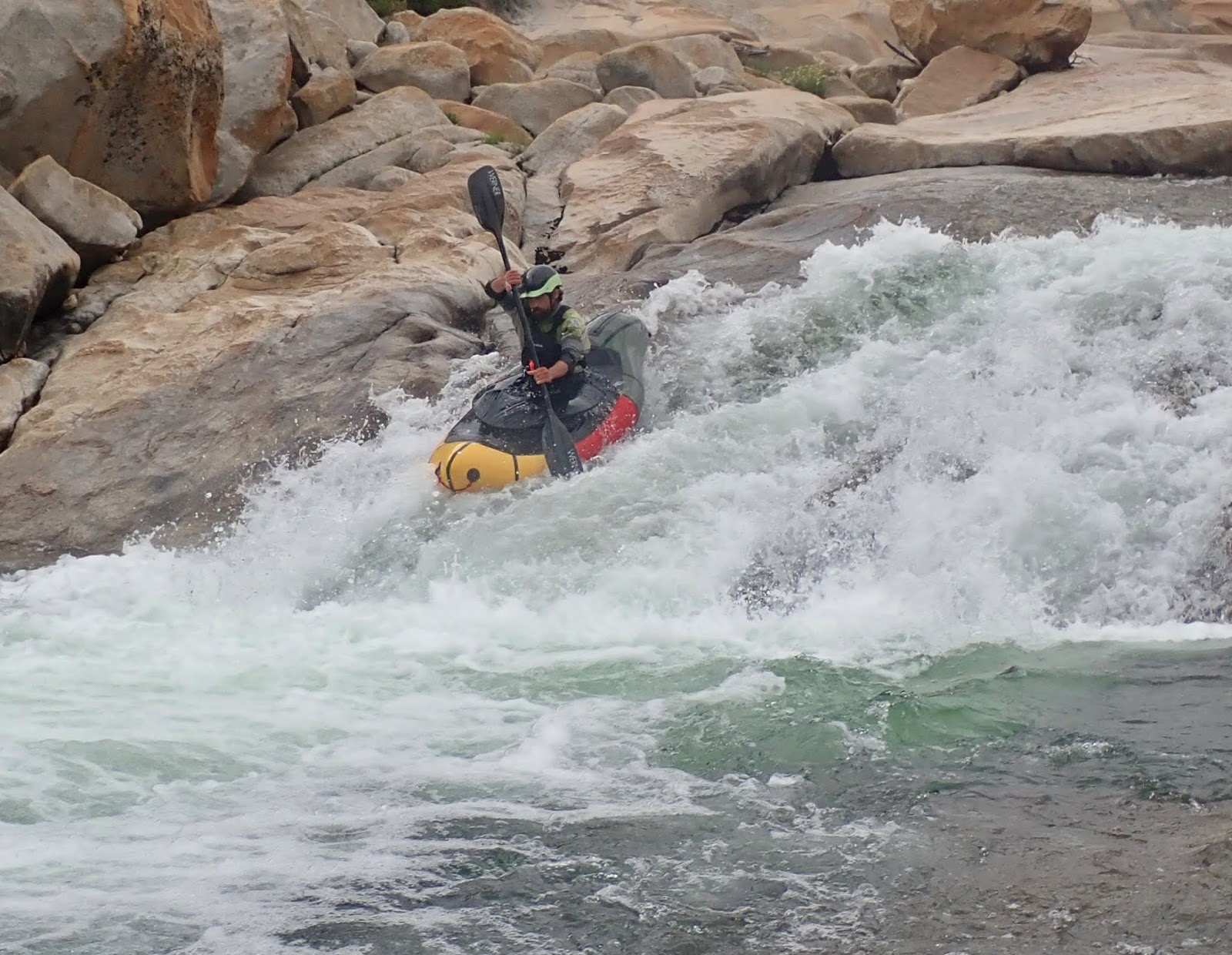
But we got in some fun drops:


 |
| A different kind of "white room" |
We continued to carefully pick our way down, and while the
intensity lifted somewhat, there were still plenty of gradient, big drops and
two more gorges to navigate before the placid waters of Cherry Lake. The Red Rock Gorge was the next major
obstacle, and we picked our way down, again running what we could and portaging
what we weren’t willing to run. It was
here that my hunger pangs and mental tenacity started to wear on me, and after
a long day I was getting a little concerned that either fatigue or impatience
might lead to some mistakes that would be unaffordable with an hour or so of
daylight left. Some of the bigger drops looked pretty good, but even as Jeff
was talking about mounting up for them, I found myself scanning the slabs for
body-sized pockets that were flat and wide enough to contain a sleeping
person. However, Jeff pointed out that a
long quarter mile and a hundred vertical feet below it appeared that the walls fell
away and the white granite gave way to tall ponderosas. So we came to an
easy compromise: Jeff agreed to portage the biggest drops, and I sighed and
agreed to push on through the gorge. Keeping the game on, we ran the
last few drops and indeed gratefully paddled through a nice pool below the last
rapid in the gorge onto a white sand beach at the foot of some huge trees, and
I admitted that this was a far better campsite than a slopey hard slab perched
above a class 5 rapid.


Upper Cherry doesn’t give itself up easily, even at the end. A tantalizing glimpse of the shimmering lake
below:

is tempered by the reality of more big drops:

 |
| I'm quite proud of this shot of Jeff; I assume it'll be in the 2020 Alpacka calendar! |
and yet another gorge stuffed with class 5
rapids leading into the lake. Again we
portaged the entire section, and then even the last 3 foot ledge held the only
logs we’d seen on the river. So we just
chugged overland and flopped directly into the lake for the mile+ paddle
out.
It’s very possible that hard dude kayakers may be a bit disdainful
of what may – or may not! – be the first pack raft descent of Cherry Creek
since we portaged much and didn’t tackle the marquee gorge, but we didn’t give
a shit; it’s one of the most incredible creeks on the planet, and we felt
fortunate to be able to dunder down it any way we could, and the fact that we
were able to paddle as much as we did made it that much sweeter.
 |
| camp in the lower right corner |