
Ever since President Clinton's surprise 1996 announcement (worth watching) of the Escalante-Grand Staircase National Monument (at the south rim of the Grand Canyon; sorta weird!) it's been the favorite whipping post by the likes of Orrin Hatch and other conservatives who barely have any teeth left after gnashing them for - already - 19 years at Clinton's audacity. And despite the fact that we've been down there a fair number of times, we hadn't really explored the breadth of the monument, and Ash's keen eye had found a couple of somewhat-obscure remote roads that enabled a medium-sized loop. And armed with The Author's (Michael Kelsey, prolific Utah desert adventurer and dizzying-guidebook creator) book on the area we had a lot of great, non-technical canyons and hikes we could do en route.
Boulder was a natural spot to start; the unusually-good Hell's Backbone Grill and Boulder Grill provide great pre-and-post tour meals, we knew we could leave our car there, and Highway 12 - between Boulder and Bryce - is a remarkable section of road that we've been wanting to ride for 15 years. And it was as good as we anticipated, with amazing views and little traffic:


We needed some lube and I found a character in Escalante who has a motorcycle repair shop in a back shed, and I figured anyone who had a sign that said "Welcome Bikers of The World" would be keen to help out a cyclist:
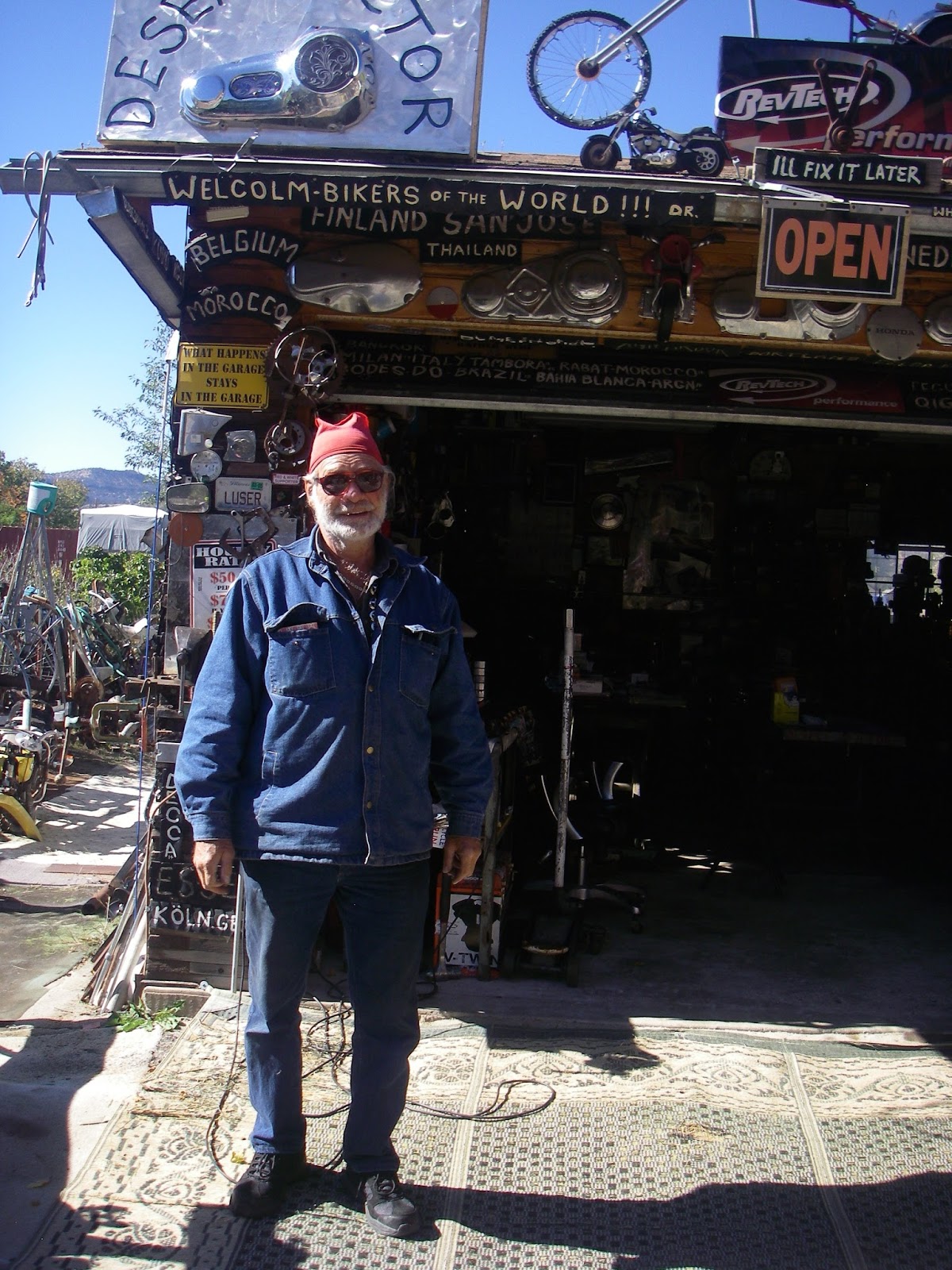
And I was right. He wisely moved there and started up just after the Grand Staircase-Escalante (heretofore referenced as GSENM) was designated in anticipation of the tourism it would bring, and has thrived (more on that later).
Near the end of the day we caught up with David, a guy who's been touring over half-time for the last 30+ years:


Whom we bid adieu at the Kodachrome Basin turnoff, since - even though he'd never been there despite going past it "probably 10 times" - he didn't want to pay the entrance fee. I suppose that's part of why people are able to make a career out of bike touring.....
But our camp fee was offset by the nice fellow campers who -as always -were happy to donate some cold beer to the scruffy cyclists' cause:
 |
| who could resist this smiling young thing when she's begging for beer? |
Kodachrome Basin is great; as beautiful as a national park but with very few people, and unlike a national park, you can ride on their easy singletrack trails!


and they have hiking-only trails as well:
 |
| getting ready to jump? |
here's to some progressive park management! (maybe we should give Utah control over all the federal lands?!?!)
And speaking of federal lands, I never really knew (actually, had given much thought to) why it was called the "Grand Staircase". Basically it's a 'staircase" of thick rock layers that work their way up from about the Grand Canyon level upward. Here's a schematic:

We had been told that southern Utah had had it's rainiest summer/fall ever, and it showed:
 |
| mushrooms growing near cacti. |
And the rains had created some interesting situations:
 |
| ah, we'll be fine! |
After hiking and riding around Kodachrome for half a day we noodled down the closed Cottonwood road for a few miles to Round Valley, where we found a good water source;

And a great slot canyon:


 |
| the remains of the last poor chaps to attempt this burly canyon |
it rained late that night, and when I woke and heard it, I also started hearing the many voices in my head that had said "Cottonwood Road is a desperate mudfest after a rain". Fortunately the next day dawned bright and clear, and the road dried quickly, except for a steep, north facing hill that was indeed a bit "desperate!"
We stopped at the amazing Grosvenor Arch


the base of the arch had a couple of things that made me re-think my enthusiasm for state park administration:
 |
| The geologic and historical info is nice, but "nature's lullaby" gets a bit carried away.... |
 |
| maybe the park service ran out of money and could only afford half of a bench? or they figured that anyone who could drive to an arch parking lot could lunch while sitting unsupported? |
We continued our progression down the Cottonwood Road, which is famously beautiful and -because it was closed - was totally car free.


halfway along the road is another roadside slot that's a great 1-2 hour sidelight:


 |
| Ash can't resist kicking up her heels at how awesome this is! (and look at the height of that jump!) |
More sublime riding took us down the road:


with only one creature we had to share it with:

the road was beat up in places:


With an hour of cleaning the unreal goo resulting:

We kept working our way down the Cottonwood road pretty slowly, since there's so much good hiking. The Cockscomb Ridge is to the east:

and the surreal Yellow Mountain to the west:

and Castle Peak looming to the north:
 |
| Gratuitous "the two of us in someplace cool" shot... |
We got to the Paria Box, which became infamous a few years ago when some rogue locals did a flagrantly illegal ATV ride up into the wilderness study area. It's clear that they haven't changed their ways much:
 |
| that's a "wilderness study area" sign |

When we had made David with his Bob trailer and his flag waving merrily behind him I realized I had forgotten my own flag. But later I happened upon a flag alongside the road that I appropriated, and hoped that it's message would alleviate any possible acrimony we human-powered types might face:
 |
| yeehaw! |
ironically, the Paria Box is nice, but not that special, relative to many other places in the area:

 |
| and boy does it have some burly hiking! |
 |
| the Paria made some cool conglomerate balls when it flooded recently |
Back on bikes, Ash was super stoked;

we saw a bit more road damage due to lack of culverts:

There was one culvert on the entire stretch:

and then we arrived at the obstacle that had the road closed:

We were able to navigate around this, but it will take a fair bit of effort to repair. Apparently it's indicative of the animosity between the local and federal jurisdictions: it's a county road through a federal monument, so who pays to fix it?
Our next stop was the White House campground near where highway 89 crosses the Paria river, 40 miles above the confluence of the Paria with the Colorado at the Lee's Ferry GC put in. A beautiful spot:
 |
| sunrise, with the full moon |
Our mission was to get a shuttle to go around to the Buckskin Gulch/Wave trailhead and then hike back the 20 miles to our bikes. Buckskin Gulch is regarded by many as The Best Slot in the World, and while the criteria of "the best" may vary, it's remarkably beautiful, and is 13 miles long!
 |
| Red Leader, we're goin' in..... |
 |
| In |
 |


 |
| moss in the desert; this place doesn't see much sun this time of year.... |
 |
| there was a bit of mud |
 |
| and a bit of water |
 |
| channeling my inner Colter for an artsy shot of sunlight shimmering on muddy water.... |
 |
| The wading started to get serious, so serious canyoneers got serious |
Katie Lee, Glen Canyon, 1961:

 |
| Ashley Patterson - doing her best Katie Lee - 2015 |
 |
| Anastazi cartoon |
 |
| Cartoonish guy trying to act all Anastazi |
it gets sorta tight in sections:

 |
| with some bigass boulders |
 |
| the old i-phone can capture good light pretty well.... |
 |
| another gratuitous "in a cool place" shot. It's a pretty cool place... |
 |
| One little downclimb had some "moki" steps (like fire rings, white men need to go big...) |
and then we hit the Paria, took a left (important!) and walked 8 miles of a slightly-bigger "slot" back to camp.

We knew that rain was coming, which made us go deviate from plan A - which was go return to Escalante by the Smoky Mountain Road, an 80 mile section of remote, waterless road that climbs up to and traverses the Kaparowits Plateau and has an even-more fearsome reputation for a road surface that turns to gumbo in the rain - and head for Kanab.
 |
| back on the rainy road with plastic bag gloves, but she's still smiling.... |
 |
| knowing that a motel room and warm shower awaited! |

But the storm moved through quickly and we were back on the road the next day in clear skies.

Our plan B was to go 16 miles up the paved Johnson Creek road to a Y, then take the Skutumpah Road back towards Kodachrome Basin. Another dirt/gravel road with a good handful of easy slots to do. The crux question: how much gravel vs dirt was there, and how fast would it dry? We hit the initial section of dirt and it was damp but very rideable, so we kept going.


18 miles of pushing through bike-stopping mud wasn't realistic, so we turned about and strategized about Plan C. we went back to our Y and then headed NW towards highway 89, to take us up to Bryce on the main highway.
happy to be back on dry dirt:

We figured if this car could make it, we could:

and eventually onto the World's Nicest Cycletrack from Red Canyon to Bryce:

From Bryce it was about 70 miles back to Boulder on Highway 12 (with some more great slots we hiked on the outskirts of Cannonville) which, though it was indeed our plan C, we had to admit it's about as good as road riding gets, and seeing over a dozen Euro bike tourers on that road reminded us that people come a long ways to ride this iconic section of highway.
As we traveled through the GSENM I had a recurring thought: "what is it that makes people so uptight about Clinton's designation of this?" It's no different now than it was before, with the exception that the communities on the perimeters are thriving: the aforementioned moto mechanic has made it happen in Escalante, there's another new gear store in that town, a nice new school there, and in Kanab there are three new big hotels going in, probably tripling the existing bed count. The owner of Kanab's (excellent!) Rockin' V restaurant said he regularly has people waiting two hours for a table! Brian Maffly did a great investigative story on the area and it seems clear that the old school types in that part of the world refuse to acknowledge the benefits of the federal designation, something that the Rockin' V guy corroborated. And cattle grazing continues - with BLM grazing fees at the silly level of something like $2.35/cow/year. The big exception is that there is no mining allowed, and apparently it's that simple fact that feeds the likes of Senator Orrin Hatch's bitterness ("When President Clinton designated the Grand Staircase-Escalante a monument, I called it ‘the mother of all land grabs.’") that must have rotted out what few teeth he may have left.
Regardless of Orrin's blatherings, it's a great place for a bike tour/hike combo, and we'll be back with our steel camels to give our plans A and B another go.
Awesome story!
ReplyDeleteGreetings from Austria.
Veronika and Rainer